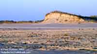
 The
dynamic landscape of the Outer Banks is utterly amazing.
Tiny grains of sand, uncountable, individually insignificant,
yet all together they combine to create the fascinating
landscape of the Outer Banks. Even as tiny as they
are, each grain of sand is thousands of times larger than
the molecules of air and water which move and shape this
landscape every second of every day. These molecules are
so tiny they cannot be seen under a microscope, yet they
push the sand about in a restless frenzy, and have done
so for hundreds of thousands of years. And still these
Outer Banks remain. The
dynamic landscape of the Outer Banks is utterly amazing.
Tiny grains of sand, uncountable, individually insignificant,
yet all together they combine to create the fascinating
landscape of the Outer Banks. Even as tiny as they
are, each grain of sand is thousands of times larger than
the molecules of air and water which move and shape this
landscape every second of every day. These molecules are
so tiny they cannot be seen under a microscope, yet they
push the sand about in a restless frenzy, and have done
so for hundreds of thousands of years. And still these
Outer Banks remain.
| This
site uses GPS coordinates where applicable,
displayed in red in the decimal degrees format
(hddd.ddddd°).
As coordinates are collected, they will be
retrofitted to existing information, and incorporated
into future information. (More
info and conversions) |
|
This is a continual and natural
process. Wind and currents keep the sand moving, slowly
washing away from one area, only to be piled up in another
area, changing the contours of the shoreline. This process
also changes the depth of the water, both in the ocean
and the sounds. The channels which connect the sounds
to the ocean, allowing water and sea life, and boats,
to move between the ocean and shallow protected sounds,
are called "inlets". These inlets also constantly change
shape and depth.
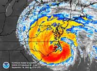 |
| Hurricane
Isabel slams the North Carolina coast in this enhanced
infra-red GEOS-12 satellite image from NOAA. |
When
nature gathers its humbling might into monstrous storms
and punishes these shores with a vengeance that makes
man flee in fear, the sand gives way under the onslaught.
Like a Willow in the wind, this flexibility allows the
Outer Banks to hold its own against the oceans unrelenting
fist.
Hurricanes, tropical storms and
"nor'easters" can drastically accelerate this sand movement.
The high water can eat away at the protective beach dunes,
or wash them completely away, or rapidly fill an existing
inlet with sand. Dramatic changes such as these that would
normally take years, decades or even centuries to happen,
can occur in only a matter of hours in one of these storms.
And sometimes, usually only once in a lifetime, a storm
will even slice a new inlet across the barrier islands
just as quickly.
|
 |
This
USGS aerial photo was taken just
3 days after Isabel created the new inlet. |
Inlets
Come And Go:
The Case of Isabel Inlet-
Hurricane Isabel reached the status
of a category
5 monster, as bad as they come, but weakened to a
category 2 by the time it pounded the Outer Banks in the
middle of September of 2003. Even as a category 2, its
rain and hail and wind caused havoc far into the piedmont
of North Carolina as it cut northwest across
the northeastern end of the state. Power outages persisted
for days, even so far from the center of Isabel's destruction
as Alamance and Guilford counties, and points west. The
Outer Banks from Carova and points inland, all the way
southward to Cape Lookout, suffered extensive damage.
On September 18th, within a matter of hours, a new inlet
was cut across Hatteras Island, severing the southern
end of the island.
 |
| This
telephoto image by the author shows a close-up of
the building that washed into the sound. |
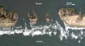 The oblique
aerial photo from the USGS (above right) and this
overhead
aerial photo from NOAA at left show two bird's-eye
views of the newly created inlet, located between the
villages of Frisco and Hatteras. (The location can be
found on the Coastal
Guide Map.) Dunes, power lines, utility pipes and
a section of NC Hwy. 12 were completely swept away here.
Oceanfront buildings were demolished or carried away by
the high water. One building can be seen where it came
to rest in the sound, visible in the USGS
photo as a small white rectangle to the right of the
label "Sound".

This detail section from the USGS aerial photo
farther above is labeled to provide visual orientation
with the other photos below. |
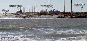
Compare this ground-level photo (looking southward
from the Frisco side of the inlet) with the detail
photo above. The "foreshortening" affect of the
telephoto lens makes the buildings look much closer
to the inlet than they really are. |
The
new inlet was dubbed "Isabel Inlet". Since the ferry dock
is located at the south end of Hatteras village, it could
not be reached. Road damage, bridge damage and building
debris in the village added to the problem. Even the Ocracoke
end of the Hatteras-Ocracoke ferry crossing was closed
down because Hwy. 12 was damaged so badly the ferry docks
there could not be reached from Ocracoke village. Though
Ocracoke village could still receive supplies by regular
ferry from Cedar Island and Swan Quarter, only a small
passenger shuttle ferry was available for Hatteras village,
and it was limited to residents and emergency personnel.
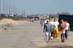 |
| Old
and young alike walked the mile from Frisco Pier
to the new inlet to see what Isabel had done. |
Non-residents
were not allowed onto the Outer Banks for two weeks after
Isabel because much of Highway 12 was covered in a deep
layer of sand and the pavement was damaged or washed out
in many places. Much storm debris had to be removed as
well. But once visitors were again allowed access, many
came to see this natural wonder, the new inlet, which
had sliced off the southern end of Hatteras Island. Vehicles
could only reach as far south as the Frisco pier on the
south side of Frisco. From there it was a mile
walk down Hwy. 12 to reach the inlet. |
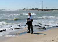 |
| The
author at Isabel Inlet. |
 |
| Wide
angle view of Isabel Inlet from ground level. |
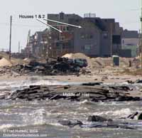 Standing
at the edge
of Isabel Inlet on the centerline of a shattered and
jumbled Hwy. 12 was an eye-opening experience. Crumbled
asphalt lead right into the ocean where the highway had
been only days before. Looking across to Hatteras Village,
the two
small "islands" remaining in the middle of the inlet
were covered with crumbled asphalt, evidence that the
highway had previously crossed there. At right another
photo plainly shows a turquoise pipe and a large black
"spiral" pipe which carried utilities, now ripped
apart and uncovered by the storm. Standing
at the edge
of Isabel Inlet on the centerline of a shattered and
jumbled Hwy. 12 was an eye-opening experience. Crumbled
asphalt lead right into the ocean where the highway had
been only days before. Looking across to Hatteras Village,
the two
small "islands" remaining in the middle of the inlet
were covered with crumbled asphalt, evidence that the
highway had previously crossed there. At right another
photo plainly shows a turquoise pipe and a large black
"spiral" pipe which carried utilities, now ripped
apart and uncovered by the storm.
Even though the power poles had
already been replaced by the time Hatteras Island was
opened again to visitors, services to the isolated and
devastated Hatteras village still were not restored. There
was too much damage to the infrastructure and buildings
to allow power back on (more about the structural damage
in Hatteras Village is covered ahead on page 2).
The inlet itself was closed in November
of 2003 by filling it with dredged sand, and the missing
section of Highway 12 was replaced. Highway 12 and Hatteras
Village finally opened to general public access on November
22, and the normal ferry schedule resumed between Ocracoke
and Hatteras at noon on that same day. |
 |
| Another
view of Isabel Inlet. |
The Isabel Breach-
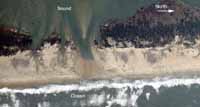 |
| The
breach between Hatteras village and Hatteras Inlet
is shown in this aerial photo from NOAA. |
The
dramatic creation of Isabel Inlet north of Hatteras village
got all the "press", but Hurricane Isabel nearly created
a second inlet on the south side of Hatteras village as
well. This second location received little mention in
the news. It is, however, a perfect example of what is
called a "breach". This happens when a storm creates a
wash across the barrier island that is only deep enough
for high tide or wave surges to wash across, but too shallow
for a constant flow of water.
 |
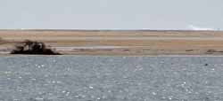
| The
breach, after it was filled with dredged sand, viewed
from the sound side on the Hatteras-Ocracoke ferry. |
 |
| This
telephoto version of the above photo shows waves
are still visible over the sand-filled breach. |
The
NOAA aerial photo above clearly shows the
breach. Sand and vegetation on the sound side of the
island is washed away creating a notch on the sound side
which did not fully cut across to the ocean. The ocean
side of the breach is dark and wet where waves break across
it. Left to nature, such a breach may fill in naturally,
or instead may continue to erode away until it too becomes
a small inlet.
 |
| Isabel
Breach after it was filled in, viewed from the beach
looking toward the sound. (N 35.20028 W 075.71608) |
Unlike Isabel Inlet, this breach
had little impact on residents or visitors, since it was
situated south of Hatteras village, where there are no
roads or buildings. The only access to this area is by
4WD along the ocean beach (Ramp
#55), which is the path used to reach the extreme
southern tip of the island at Hatteras Inlet where fishing
is a popular activity. An inlet here would only cut off
4WD access to the area for fishing. Still, authorities
chose to fill the breach with dredge sand. The wide angle
and telephoto images at right, taken from the Hatteras-Ocracoke
ferry, show the area of the breach from the sound side
after
it was filled in. In the telephoto shot waves
can clearly be seen across the sand on the ocean side.
From this it becomes obvious the land is not very high
here. The absence of high beach dunes, which would normally
block such a view, leaves the area vulnerable to future
storms. |
The
Case of New Inlet, Pea Island-
The Pier in the Marsh
 Smack
in the middle of Pea Island National Wildlife Refuge,
at mile marker 34 (GPS coordinates N
35.67510 W 075.48084) on Hwy.
NC 12 is a strange sight. What looks to be a very long
pier sits
in the shallow marsh. It is a curiosity for certain,
as there would seem to be no logical reason for a great
long pier to be there. Smack
in the middle of Pea Island National Wildlife Refuge,
at mile marker 34 (GPS coordinates N
35.67510 W 075.48084) on Hwy.
NC 12 is a strange sight. What looks to be a very long
pier sits
in the shallow marsh. It is a curiosity for certain,
as there would seem to be no logical reason for a great
long pier to be there.
 This old "pier" is in actuality
an old bridge. This area of Pea Island is still known
as "New Inlet", and it clearly exemplifies the dynamic
nature of the Outer Banks. This was one of those inlets
that came and went, more than once. Though the name "New
Inlet" has often been applied to other inlets which appeared
along these barrier islands, this particular "New Inlet"
appeared north of Chicamacomico (Rodanthe area) sometime
in the 1730's. It was always fairly unstable, partially
filling, then widening again in cycles through the decades.
Then, close to 200 years later, in 1922, it closed completely.
 But just eleven years later, in
the fall of 1933, hurricanes again opened the inlet, cutting
two channels across the very center of what is now Pea
Island National Wildlife Refuge. Though there was no Hwy.
12 or any other actual road along these islands south
of Oregon Inlet prior to the end of World War II, this
was the era when the "motor car" was beginning to make
itself useful as a means of transportation via the beaches.
But passage along the beachfront, or elsewhere on the
islands for that matter, still required a means to cross
the inlets. These newly cut channels were narrow and lent
themselves to being bridged, unlike the wider inlets,
which made a ferry more economically practical than bridge
building. So two wooden bridges were constructed across
the inlet channels, only to see the inlet close once again
soon after the bridges were put into operation.
Today the remnants of these old
wooden bridges attest to the inlet's existence, looking
curiously out of place across the marsh grasses of Pea
Island. One of these bridges is still recognizable, shown
in the telephoto
view at right above. The other bridge is now marked
only by rows of pilings, which can be noted in the aerial
photos below.
 |
| This
composite detail better shows the bridge remains. |
 |
| Two
aerial photos from NOAA were composited to created
this image of the Pea Island "New Inlet" area. |
The
composited aerial
photo from NOAA at left, and a close-up
of the same composite at right, clearly show the former
path of the road as it swung away from the beach and crossed
the two bridges, then swung back toward the beach again.
The south bridge (left in the photos) is now only a line
of pilings, but enough of the north bridge (right in the
photos) remains that it is easily visible from Hwy. 12.
Next, see what can happen to beach
dunes, even if they're two stories high, and marvel at
an ancient forest in the surf. |
|


