map

North Carolina's Outer Banks and coastal areas are replete with state and national parks, reserves and other recreational facilities. Hunting, fishing, bird watching, boating, camping, hiking, kayaking, biking, and many other activities can be enjoyed in the many thousands of acres of these protected land and water areas. Historical and cultural sites, museums and educational displays dot the coast as well. Below is but a partial listing, with each location linked to an "official" web site.
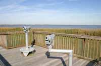
Viewing platform in Mackay Island National Wildlife Refuge
Parks and other facilities of
North Carolina's Outer Banks and Coast


Above: Geese flying just before sunset at Pea Island National Wildlife Refuge.
Below: Camping near the Point at Cape Lookout.

Above: NC Aquarium at Pine Knoll Shores. Below: Mallards on Ocracoke.


Related Links -

Bird Checklists of NC
US Geological Survey


Beach Ramp access
map and information

NOTICE: Follow the ramp access link above for Important 4x4 access news

 
Copyright © 2003 Fred Hurteau           * Copyright information and image use policy *

 
home about map parks sports ferrys birds wright lighthouses folklore JRidge ocracoke Scenig Places Ferrys Wild Horses dynamic contact gallery Shipwrecks