 |
Cape
Hatteras Lighthouse
in 1973. |
Why
Was Cape Hatteras Lighthouse Moved?
There
is indeed something awe inspiring and mystical about this
lighthouse, more so than any other. It is not unusual
in the height of tourist season for 1000-2000 people per
day to climb the lighthouse, with many hundreds of thousands
visiting the park each year. Its magic is apparent in
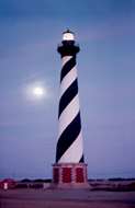
this photo
as the pinks and violets of a fading sunset wash over
the lighthouse. A rising moon behind wispy clouds competes
with the lighthouse beacon in the evening sky.
But this wasn't the first Hatteras light. Its predecessor
was built in 1803 just 600 feet southwest of where the
current light stood for 130 years. The original light
was insufficient for the job, as was its foundation. In
the winter of 1868 construction began on the current structure,
supervised by a reputable builder named Dexter Stetson.
It was completed in 1870. (Stetson also constructed the
Bodie Island Lighthouse in 1872.)
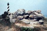
The remains of the 1803 lighthouse foundation, captured
in this 1973 photo, ( below left ) is now gone;
washed away in 1980 by a severe storm. |
Cape
Hatteras Lighthouse in1973.
|
The
location for the 1870 construction, mandated from Washington,
was a major mistake. In 1850 the beach was 2500 feet east
of the lighthouse. But by the time construction started
on the 1870 structure, the ocean had already moved 1000
feet closer. By 1919, a half century later, the beach
front had eroded to within 300 feet of the light. Luckily,
the erosion rate slowed drastically, and though the shape
of the beach shifted, it remained essentially the same
distance from the light for several more decades.
|
| From
1930 to 1968 several ideas were tried to hold back the advancing
ocean, even after the U.S. Coast Guard abandoned the lighthouse
and gave it to the National Park Service. A barrier sand dune
system was built, steel pile groins were installed, sandbags
were put in place and thousands of tons of sand was brought
in. |
 Then
in 1968-69 the Navy built two concrete seawalls to protect
the small Navy installation next to the lighthouse, and
as an afterthought, one more to protect the lighthouse
itself ( see photo at left ). But still the battle continued
against the encroaching ocean. The steel pile groins were
extended, more sand was brought in ( 1.5 million cubic
yards ), and even artificial seaweed was "planted" to
hold the sand in place. But none of it worked for long. Then
in 1968-69 the Navy built two concrete seawalls to protect
the small Navy installation next to the lighthouse, and
as an afterthought, one more to protect the lighthouse
itself ( see photo at left ). But still the battle continued
against the encroaching ocean. The steel pile groins were
extended, more sand was brought in ( 1.5 million cubic
yards ), and even artificial seaweed was "planted" to
hold the sand in place. But none of it worked for long. |

Bold
Action For A Grave Situation
The
National Park Service considered many proposals to solve the
erosion problem. Then in 1989 they announced their desire to
pursue the option of moving the lighthouse.
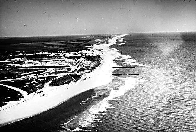
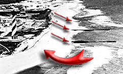
In the older
black and white photo from NASA ( above ), compare
the area in front of the lighthouse marked by the large red
arrow with the same area in the
color aerial photo ( right ), taken by the N.C.
Dept. of Transportation in April, 1997. It is quite easy to
see why the situation was grave. |
 Click image
for larger view.
Click image
for larger view. |
With the lighthouse on the brink of disaster, the idea of moving
this historical and aesthetic treasure was hotly debated. But
in the end, the move as recommended by the National Academy
of Science's, and later endorsed by a team of NC State University
engineers and coastal geologists, was approved and funded.
The North Carolina Lighthouse Society article on the
history of the Cape Hatteras Lighthouse offers more in-depth
information. |
|
|