|
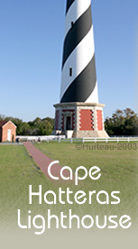
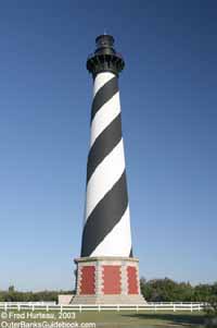
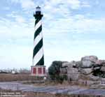
 Cape Hatteras Lighthouse
Fact Sheet:
- Completed
- (activated) Dec. 16, 1870
- Height
to top - 198 feet, 2½ inches (tallest masonry lighthouse
in the U.S. and the second tallest brick light tower in
the world.
Figures at the new location, as given by the National Park
Service, are as follows:
- Tip of the spire - 210.01 feet above Mean Sea Level
- Tip of the spire - approx. 197.5 ft. above ground
- Height
to focal plane - 192.2 ft. (new location)
- Beacon
Type - 2 DCB-24 rotating beacons back to back with 1000
watt lights focused by parabolic reflectors
- Beacon
distance - 24 nautical miles (about 20 statute miles)
- Light
pattern - rotating beacon, 7½ seconds between lamps
(15 sec. per complete rotation for 8 flashes per minute).
- dusk to dawn
- No.
of lighthouse steps - (depends on which steps you count)
- 9 granite steps from the sidewalk to the inside, 248 cast
iron steps to reach the gallery, and 12 more to the lantern
room. Thus, visitors climb 257, Keeper climbs 269.
- Open
to public to climb - Yes (approx. Good Friday/Easter through
Columbus Day or week of Columbus Day)
- Location
- near Buxton:
Plaque in lighthouse gives 35° 15' 14" N Latitude and
75° 30' 56" W Longitude, though the National Park Service
gives the original (pre-move in 1999) coordinates as 35°
15' 18.6" N latitude, 75° 31' 10.5'W longitude,
and gives the new coordinates after move as 35° 15'
01.92560" N latitude, 75° 31' 43.74342'W longitude
- Keeper's
Houses - Duplex Asst. Keepers Quarters open to public as
visitor center/museum. Brick Keepers Quarters not open to
public.
- Management
- Beacon operation maintained by the U.S. Coast Guard. Lighthouse,
grounds and visitor center operated by National Park Service.
- How
to get there - From NC 12 on east side of Buxton, turn south
at lighthouse grounds entrance marked by signage.
|
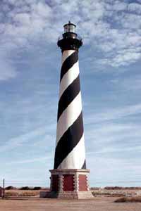
Cape Hatteras
Lighthouse in 1973.
|
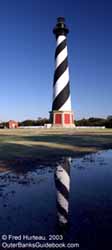
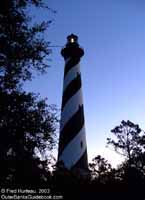
Cape Hatteras
Lighthouse in 2003.
|
In
1999 the Cape Hatteras Lighthouse, weighing about 3000 tons,
was physically uprooted and moved more than half a mile (on
the next page you
will learn more about why the lighthouse was moved). It still commands the same awe it has always
deserved, but the atmosphere surrounding it is quite different.
It is a major attraction, and it's being treated like one. Park
personnel see that everyone stays in line and follows the rules,
like waiting in line at a theme park to ride the "Super Duper
Thriller".
 Thirty years ago things were far more
casual. There were no park personnel to supervise visitors.
It was each curious visitor for himself. The 1973 photo at right
shows a large
crowd around the gallery. The photo at left, also taken
in 1973, shows the old location, just 600 feet away from the
foundation remains of the 1803 lighthouse that preceded the
current structure. SInce this old
foundation disappeared in a storm in 1980, and the lighthouse
was moved in 1999, the same photo taken today would show nothing
but sand and sky.
Thirty years ago things were far more
casual. There were no park personnel to supervise visitors.
It was each curious visitor for himself. The 1973 photo at right
shows a large
crowd around the gallery. The photo at left, also taken
in 1973, shows the old location, just 600 feet away from the
foundation remains of the 1803 lighthouse that preceded the
current structure. SInce this old
foundation disappeared in a storm in 1980, and the lighthouse
was moved in 1999, the same photo taken today would show nothing
but sand and sky. |
 |
 NOAA
photo (above) NOAA
photo (above)
 |
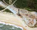
The
National Oceanic and Atmospheric Administration (NOAA) took
aerial photos of the entire Outer Banks, including all the lighthouses,
in September, 2003, just after Hurricane Isabel. You will notice
in these photos several areas of standing water left after the
hurricane. Though these photos have been reduced somewhat in
size, they are still quite large. In all four images, east is
to the left.
Photos Aerial
One, and Aerial
Two are detailed views of the new lighthouse site. Aerial
Three includes the old lighthouse location next to the beach
so the relationship can be seen. And as a special treat, Aerial
Four is the same photo with the lighthouse and Keepers Quarters
buildings digitally placed back where they originally were (just
for old times sake). |
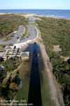 |
The
panoramic photo above. taken about a month after the aerial
photos, is looking
east from the lighthouse, and shows the path taken by the
lighthouse when it was moved. The patch of sand next to the
ocean (top center in the photo) is the old location of the Cape
Hatteras Lighthouse. Left is another photo looking east with
Cape Hatteras Lighthouse casting its shadowy
finger toward its old home. 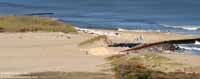 Below
right is a telephoto view from the lighthouse gallery, showing
the old
lighthouse location next to the beach. The whitish oval
ring, left of center, is where the lighthouse stood. The protective
dunes were almost completely washed away by Isabel, and the
beach was seriously eroded farther along the old groin. Below
right is a telephoto view from the lighthouse gallery, showing
the old
lighthouse location next to the beach. The whitish oval
ring, left of center, is where the lighthouse stood. The protective
dunes were almost completely washed away by Isabel, and the
beach was seriously eroded farther along the old groin. |
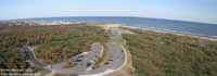
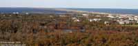 The
panoramic photo at right shows the view
north from the lighthouse at its new location. Looking south
from the gallery (photo below) affords a great view
of Cape Point. Here too, the dunes were washed completely
away by the fury of Hurricane Isabel. In fact, there are no
dunes left at all between the lighthouse and Cape Point. Two
views looking north from Cape Point (below center & right) also
show a communications tower south of the lighthouse.
The
panoramic photo at right shows the view
north from the lighthouse at its new location. Looking south
from the gallery (photo below) affords a great view
of Cape Point. Here too, the dunes were washed completely
away by the fury of Hurricane Isabel. In fact, there are no
dunes left at all between the lighthouse and Cape Point. Two
views looking north from Cape Point (below center & right) also
show a communications tower south of the lighthouse. |
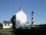 |
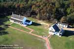
The
new
site is arranged identically to the original location (top
left photo). The duplex Assistant Keeper's Quarters serves as
a visitor center and museum. The brick main Keeper's Quarters
is not open to the public. The lower left photo shows the lighthouse
view
from the west end of the duplex Keeper's Quarters.
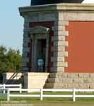
The entrance
to the lighthouse base gives the illusion that the lighthouse
is not really so tall after all. But once you see the entrance
compared to a person, the true grand scale of the door, the
base, and the lighthouse itself is suddenly quite evident (upper
right). |
click
thumbnails for
a larger view 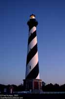 |
|
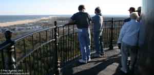 
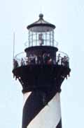
The
best view in town is, of course, from the gallery
atop Cape Hatteras Lighthouse. And on an especially clear
day, with the light from the west, if you look southeast very
carefully out over the ocean, you might see a faint glimmer
on the horizon. And if you remembered your binoculars, you may
be able to tell that the teeny tiny shimmering you can almost
see is the Diamond
Shoals Light Tower, 13 miles away! It and the Frying Pan
Shoals tower both are in deplorable condition and scheduled
for demolition by 2004, but funding is still pending. |
 |
There's
more to see at Cape Hatteras. Go inside the Keeper's Quarters,
and inside the lighthouse itself on page two. |
| Continue
to Cape Hatteras Lighthouse - Page
Two > |
Cape
Hatteras
Lighthouse |
 |
|