 |
||||||||||||||||
 |
 |
|||||||||||||||
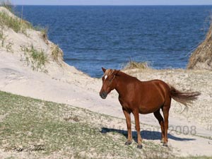 It is possible to find the wild Spanish mustangs along much of the beach from Corolla to Carova. But most of the nearly 11 miles of beach from the ramp at Corolla to the Virginia line at Carova looks pretty much the same. It is very difficult to know where you are. There are very few distinctive landmarks to go by, and there simply are not any road signs other than some hard to spot mile markers. You will quickly find that having some frame of reference to judge your location relative to the Corolla ramp or the Virginia line will bring you peace of mind. You should be mindful of the tide when driving this stretch of beach. Depending on the time of year and the weather, high tide can come very far up on the beach, near the dunes, putting you in deep loose sand with little room to drive. Being able to judge how long it will take to reach Carova or Corolla is extremely useful. Remember, driving along the beach is a lot slower than on the open highway, and you must take that into consideration when judging distance and time. The seemingly short eleven mile drive can often take from 30 minutes to an hour.  Refer
to local
tide charts to plan your best opportunities for traveling along
this beach. At times low tide opens much of this beach to a very wide
and hard packed surface, reminiscent
of Daytona Beach. At other times, even low tide will give minimal
berth, and you must grind your way for miles in soft sand. Also keep
in mind that there are no public facilities north of Corolla. No stores,
no gas stations, and no public restrooms are to be found. The closest
thing to a public facility is the Carova
Beach Volunteer Fire Dept. and Rescue Squad, located back off
the beach between MM21 and MM22. Refer
to local
tide charts to plan your best opportunities for traveling along
this beach. At times low tide opens much of this beach to a very wide
and hard packed surface, reminiscent
of Daytona Beach. At other times, even low tide will give minimal
berth, and you must grind your way for miles in soft sand. Also keep
in mind that there are no public facilities north of Corolla. No stores,
no gas stations, and no public restrooms are to be found. The closest
thing to a public facility is the Carova
Beach Volunteer Fire Dept. and Rescue Squad, located back off
the beach between MM21 and MM22.  There is one other
hazard you should be aware of that you won't find on most beaches.
There used to be an ancient maritime forest where the beach is now.
The salt water has preserved many of the stumps
from that ancient stand of trees. Sometimes they are mostly covered
by sand. At other times the sand is carried away and they are greatly exposed. These are visible
at low tide, and can be far enough up on the beach that they could
be driven into. These stumps are easily visible in daylight, but may
not be so obvious at night. Just be aware that they are present in
several places, especially along the southern end of this beach area,
and be sure to avoid them. You can read more about this phenomenon
at "Stumps In The Surf".
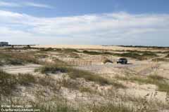
Penny's Hill The first interesting sight you come to north of Corolla is Penny's Hill. The problem is it's not visible from the beach. This large dune is located at Mile Marker 15, where there is a ramp. But this ramp is marked private, and leads to a large home (far left in photo) in front of Penny's Hill.
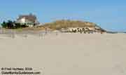
Just 200 yards north of MM15 is another ramp closest to Penny's Hill, and then another ramp 200 yards north of that one. Either of these will let you navigate the paths back southward to reach the location shown in the photo. These ramps and roads are clearly visible in the NOAA aerial photo below. It is not clear whether Penny's Hill is private property, or only next to private property. You cannot drive on this dune, but it might be possible to hike it. Other Landmarks 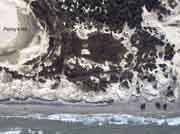 Approximately one half mile north of Penny's Hill and Mile Marker 15 is the first obvious landmark on your way north. Three beach homes sit at the dune line where they jut out onto the beach. At high tide you have to drive around behind these houses to keep out of the surf. The NOAA aerial photo at right shows the three houses on the lower right of the photo (look for their shadows on the beach) and Penny's Hill to the upper left.
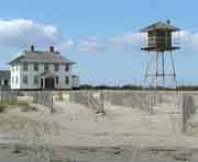
The next easy to spot landmark is the watchtower pictured at right. It sits in front of a building marked "US Coast Guard Station No. 166", which is located about seven miles north of the Corolla ramp. From here there is only another 3.8 miles to the Virginia line. This is one of several places along the beach where high tide can reach well up to the dunes, as evidenced by the dark color of the damp, packed sand in the foreground of the photo. The last easy to spot landmark is a pair of bright white verandas, or gazebos, and a boardwalk out at the dunes. These belong to a house that is 8.3 miles north of the Corolla ramp. Once you reach this area, you are getting into prime wild horse territory, as evidenced by the photo of this colt with the white boardwalk steps in the background. 
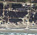 Another 250 yards
north of this landmark is the ramp leading to the Carova Beach Volunteer
Fire Dept. and Rescue Squad. Both can be identified in the aerial
photo from NOAA linked at right. This ramp, or any ramp north
of here will take you into Carova. There is a good chance you will
find wild mustangs grazing almost anywhere in the area between this
ramp and the next four ramps northward. You don't really have to worry
about getting lost. You can't go very far in any event. If you come
to a dead end, just turn around and go back. The roads generally run
in a north/south - east/west grid, with frequent crossroads. You can
always work your way east until you reach a beach ramp.
|
||||||||||||||||
| The
Wild Horses of Corolla Finding the Wild Horses of Corolla The Wild Horses of Corolla in Pictures Gallery of WIld Horses of Corolla Related Links - Dynamic Landscape - Stumps In The Surf Local Tide Charts - Duck Field Research Station Corolla Wild Horse Fund Wild Horses of Corolla Photo Gallery - Page One Page Two Page Three Page Four Page Five  Beach Ramp access map and information
|
||||||||||||||||
|
||||||||||||||||
