|
 1862
Shipwreck of the Federal Transport Oriental 1862
Shipwreck of the Federal Transport Oriental
Location: On Pea Island National Wildlife
Refuge, opposite the Pea Island Wildlife Visitor Center/Nature
Trail Information Center.
GPS coordinates: (guesstimated distance) 250 yd. due
east of N 35.71753 W 075.49232
 How To Find It: Cross Oregon Inlet Bridge south onto
Pea Island National Wildlife Refuge. Continue south to the Wildlife
Visitor Center and Nature Trail Information Center on NC Hwy
12, located 1/10 mile south of mile marker 31. Park at the visitor
center and take the foot path over the dunes on the east side
of the highway directly across from the parking lot. The boiler
stack is visible in the water, though more is visible at low
tide. Binoculars or a telephoto lens works best to view or take
photos. In the aerial
photo (above right) much of the highway and parking lot
is still covered with sand washed up by Hurricane Isabel, making
them difficult to distinguish in the photo.
How To Find It: Cross Oregon Inlet Bridge south onto
Pea Island National Wildlife Refuge. Continue south to the Wildlife
Visitor Center and Nature Trail Information Center on NC Hwy
12, located 1/10 mile south of mile marker 31. Park at the visitor
center and take the foot path over the dunes on the east side
of the highway directly across from the parking lot. The boiler
stack is visible in the water, though more is visible at low
tide. Binoculars or a telephoto lens works best to view or take
photos. In the aerial
photo (above right) much of the highway and parking lot
is still covered with sand washed up by Hurricane Isabel, making
them difficult to distinguish in the photo.
|
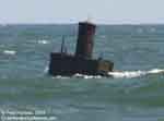 |
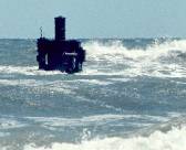
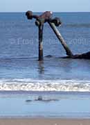
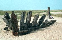
The
Oriental sank in 1862. Comparing the 2004 photo on the
left, and the 1973 photo on the right , it's obvious little
has changed in 30 years. Though low tide reveals more of the
stack, and it has developed a slight tilt to one side, there
still is no mistaking it.
 |
 |
 |
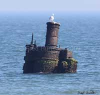
The
left image was taken in 2004 at low tide with a calm sea. The
low angle of the late afternoon sun gave a soft reddish light
that brought out details not visible in earlier images. The
green on the metal is algae growing up to the high water line
where high tide covers the metal much of the time. At right
is a more detailed image taken in 2009 with a 700mm telephoto
lens. |
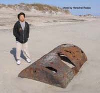 |
(above)
Herschel's nephew provides
a size reference to the tank. |
 |
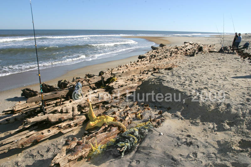
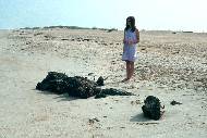
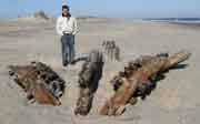
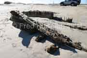
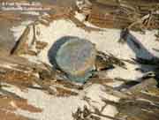
Part
of the Oriental?
In April
of 2008, a wreck report and photos arrived from Herschel Reese
concerning a large riveted metal tank found near the Oriental
site. Herschel writes, "Saw something today (03April2008) I
hadn't seen before. At the Pea Island Wildlife Refuge, go across
to the beach... [by] the Oriental stack sticking out of the
water. On the beach about 300 yards north is what appears to
be large riveted iron tank 2/3 buried in the sand, assume[d]
from the Oriental. "
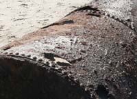
The photo
at right shows the tank's location in reference to the waterline,
which appears to be at low tide. The lower left photo clearly
shows the riveted construction of this tank in great detail.
This is obviously not some old oil drum that's washed up on
the beach. As close as this is to the Oriental site,
it seems highly likely it could be a part of the wreck that
has broken free and made its way ashore.
|
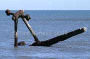
Underwater
Report on the Oriental from Marc Corbett:
| Marc
Corbett is an Outer Banks resident whose hobby is
diving on near-shore and sound side underwater wrecks. |
|
"The
shipwreck itself is running roughly parallel with the beach.
It is in about 30 feet of water, the stern is facing north and
there is a propeller. I think the bow has broken off and is
now under the sand. You can follow the tower that is the steam
engine all the way to the sand, there are a number of places
you can swim through it. There is a good bit of coral growing
down by the base. There are lots of fish on the wreck, I have
heard there are often sharks but I have not yet seen any on
this wreck. Also on the shore where the boiler is that you have
pictures of there was also some sort of cast iron tub that had
washed ashore, I have seen similar things out on the wreck and
I think this tub may have come off the wreck."
|
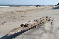
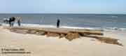
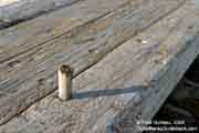
 Unknown
Wreckage (ID: UNK-Pea_Island_3-30-10) Unknown
Wreckage (ID: UNK-Pea_Island_3-30-10)
(rated as likely to wash
with a storm because of it's smallish size, and because it is
not protected by any dunes.)
Location: .75 miles south of Pea Island
Visitor Center, high up along the dune line where dunes are
washed out.
GPS coordinates: N
35.70614 W 075.48901
How To Find It: On Hwy. 12 go .75 miles south of Pea
Island Visitor Center and park along road. Walk toward beach
to find the wreckage high up along the dune line where dunes
are washed out.
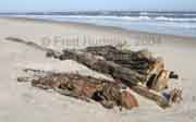
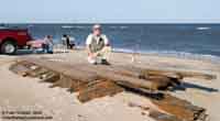
The left photo shows how this wreckage
section has two "beams" adjoining three others at about a forty-five
degree angle. The drawing at left depicts this more clearly.
Several heavy metal rods which hold the pieces together are
visible along the edges. This is very obviously a piece of a
ship.
No dimension exceeds five feet, so this
is a relatively small piece. Although it is high up where the
dunes should be, it sits exposed because the dunes are washed
away here, as shown by the two right photos. One looks from
the wreckage toward Hwy. 12, and one looks back toward the beach,
showing there are no dunes to protect it. Given it's size and
it's exposed location, it could easily be moved by a storm tide
washing through the dune gap. Pea Island has proven highly succeptible
to such high storm tides.
|
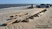
 1862
Shipwreck of the side-wheel steamer, transport Pocahontas 1862
Shipwreck of the side-wheel steamer, transport Pocahontas
(probable identification)
Location: North of first beach access ramp - south end
of Salvo
GPS coordinates: N 35.54152 W
075.46562
How To Find It: Look for the parking area on the east
side of NC Hwy 12, just south of the last building on the south
end of Salvo, and 4/10 mile south of mile marker 43. This will
be beach access Ramp #23 (though the ramp number sign was missing,
due to Isabel damage, when this was prepared in April, 2004).
You can either park and walk, or take your 4WD over the dunes
on the access road, and go 7/10 mile north on the beach. The
visible part of the wreck can be seen in the surf at high or
low tide, but more is visible during low tide. |
 |
Two
local citizens provided information which led to this shipwreck.
There was nothing about it in any Park Service or tourist bureau
information. It is said to be the Union side-wheel steamer ship
called the Pocahontas which wrecked while transporting
troops in the Civil War.
At low tide this metal hulk is sometimes close enough to the
beach that it can be waded to, as seen in the right photo. This
may not be advisable, however, as it is not known what sort
dangerous debris may lie around it.
- Thanks to Park Ranger John Benson, and to Chicamacomico
Life-Saving Station personnel for information on locating this
wreck site. |
|
Visible
often |
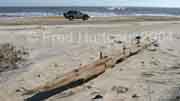
1933 Shipwreck
of the Schooner G.A. Kohler
Location: Edge of the surf at low tide,
75 ft. north of 4WD beach access Ramp #27, north of Avon (and
south of Salvo).
GPS coordinates: (as of October, 2004) N
35.47034 W 075.48127
How To Find It: This wreck site was not found in April,
2004. It WAS found, however, in October, 2004, located 75 ft.
north of Ramp #27, which is near mile marker 47, between Salvo
and Avon.
|
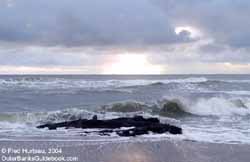
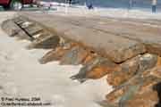
 This
1973 photo of the Kohler at left shows what was visible
then. Of course, wreckage is constantly being covered and uncovered,
at the mercy of shifting sands and storm erosion. The Kohler
was a very large ship, as can be seen by the thickness of the
ribs in this old photo. How could you know how much more was
under the sand in this photo? This
1973 photo of the Kohler at left shows what was visible
then. Of course, wreckage is constantly being covered and uncovered,
at the mercy of shifting sands and storm erosion. The Kohler
was a very large ship, as can be seen by the thickness of the
ribs in this old photo. How could you know how much more was
under the sand in this photo?
On the trip of April, 2004, however, the
Kohler was not located. This doesn't mean it isn't still
there. One report indicated it was visible in the surf, and
others put it on the beach. The author drove along the beach
from Ramp #27 north for a half mile, and then turned around
and drove south for 3 1/2 miles to exit at Ramp #30, and no
sign of the Kohler was spotted. It is supposed to be
right at Ramp #27. The tide was not optimally low, which might
have covered the wreck if it is now located in the surf. But
the reported information varied, which makes locating these
wrecks more difficult. The search will continue.
Update: October, 2004 - Kohler located
The October 2004 trip was immensely successful for discovering
shipwreck locations. The G.A. Kohler was found right where it
was said to be. But in the short 12 hour period from 8:00 pm
in the evening to 8:00 am the next morning, the surf had exposed
more of the wreckage than was visible the previous evening.
This emphasizes how fickle and fluid the business is of finding
some of these wrecks. In order to take the new photos of the
Kohler from the angle used in the 1973 photo above, you would
have to stand knee deep to waist deep in surf. Furthermore,
the wreckage in the 1973 photo is something like 100 feet from
the foot of the dunes. In October 2004 it is located only about
50 feet from the foot of the dunes. The landscape changes constantly
here, especially the beachfront. It's a wonder the wreckage
is visible at all. |
Taken
at night by headlights and camera flash |
Taken
soon after sunrise on a heavily overcast morning |
Taken
the next morning |
  Update
- Ten weeks after the above
report, this wreck site had been significantly uncovered.
Much more of it was visible, and in fact, was drier and
much lighter in color than in the October photos. These
new photos were taken December 28, 2004, at a low tide,
and show how much more of the wreck had been revealed.
The author's son standing near the wreck gives some sense
of the actual size of the beams.
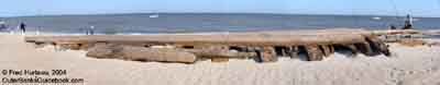
Update
- Ten weeks after the above
report, this wreck site had been significantly uncovered.
Much more of it was visible, and in fact, was drier and
much lighter in color than in the October photos. These
new photos were taken December 28, 2004, at a low tide,
and show how much more of the wreck had been revealed.
The author's son standing near the wreck gives some sense
of the actual size of the beams.
 An interesting note- although 31
years separates the 1973 photo of the Kohler in
the initial report section above and these most recent
photos, it is easy to see that the beach seems to have
changed little. It had few dunes of any size then, and
is still almost bereft of dunes near the Kohler. Although
more of the wreckage is presently above the sand, the
beach slope looks very similar. and the location seems
to be about the same distance from the dune line.
An interesting note- although 31
years separates the 1973 photo of the Kohler in
the initial report section above and these most recent
photos, it is easy to see that the beach seems to have
changed little. It had few dunes of any size then, and
is still almost bereft of dunes near the Kohler. Although
more of the wreckage is presently above the sand, the
beach slope looks very similar. and the location seems
to be about the same distance from the dune line.
 |
 |
 |
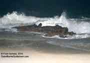
| The
far left photo above shows the large ribs which
were protruding from the sand in the 1973 photo,
all that was visible at that time. |
|
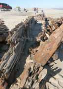
Update:
November 2008 - More of Kohler exposed
The Kohler has survived the wrath
of many hurricanes since the 1973 photo seen at the top
of the article was taken. These great timbers have been
covered and uncovered time and again by storm waves and
high tides just since the 2004 photos above were taken.
Then in November of 2008 an inspection of the site revealed
that much more of the wreck was exposed than had been
seen before. Looking at the photo from 1973 one would
never know how much more timber was actually hidden beneath
the sand. The whole north end of the wreckage was above
the sand this time, and the east side (surf side) was
exposed deeper than before. The scale of this wreckage
can be gauged by comparing it with the fishermen at the
far end in the vertical photo at right.
|
 1878
Shipwreck of the Schooner Altoona 1878
Shipwreck of the Schooner Altoona
Location: East of the Ramp #44 pond at
Cape Point, Buxton (Cape Hatteras).
GPS coordinates: A best guess based on the 1973 photographs
here puts it at that time about
N 35.230766, W 075.529690
How To Find It: The Park Service reported that it washed
away in a storm in the late 1970's or early 1980's. However,
other sources claim it is still there, though the area is now
a mucky, stagnant, swampy area infested with poisonous snakes.
|
 The
photo at left shows the Altoona in 1973. The Dare County Tourist
Bureau brochure titled "Shipwrecks & Lighthouses Along
The Outer Banks" still lists this wreck in 2004, though
it was reported many years ago as having washed away in a storm.
Other sources claim it is still here. The
photo at left shows the Altoona in 1973. The Dare County Tourist
Bureau brochure titled "Shipwrecks & Lighthouses Along
The Outer Banks" still lists this wreck in 2004, though
it was reported many years ago as having washed away in a storm.
Other sources claim it is still here.
A trip in October, 2003, and again in
April, 2004, failed to provide any indication this wreck still
exists. A concerted effort to find some traces of it in December
of 2009 also failed to locate anything, due greatly to the stagnant
mucky marsh environment that now covers the area. At the minimum,
it is no longer easily visible. The section of wreckage in the
photo was no longer than perhaps 12 to 15 feet, and appeared
to be sitting on the sand, as opposed to being partially buried.
A loose section that small could have easily washed away in
a storm, given its exposed location at Cape Point.
Note: October, 2004 - A tedious attempt to locate
the position of this old wreckage was unsuccessful. I tried
to find a location which matched the old 1973 photos by positioning
myself where the lighthouse and communication towers would line
up as seen in the old photos, taking into account that the lighthouse
had moved. I could not drive by 4WD or reach on foot a position
which came anywhere near matching the old photos. The terrain
has greatly changed since 1973. I have given up any further
attempts to locate this old site. - Fred Hurteau
Note 2: November, 2009 - I have read reports claiming
this wreckage is still visible near the end of beach ramp #
44 at Cape Point, claiming it is in a poisonous snake infested
area. Aerial photos show two "ponds" near that point which might
indicate a wet enough environment to account for snakes.
This second
photo of the Altoona from 1973 (at right) shows the wreck
from a different angle than the upper photo. It puts the wreckage
next to a pond at that time. In fact, close examination of the
full enlargement on file appears to show it at the juncture
of two ponds, which actually matches the 2009 aerial image showing
a similar pond alignment. If foot access is permitted (questionable
because of protected bird nesting sites in the area), I will
pursue this investigation based on this new information. - Fred
Hurteau
Note 3: Another search in December 2009 also failed to
produce any results. GPS coordinates were taken at that time
and adjusted to try to match the 1973 location.
|
Unknown
Wreckage (ID: UNK-1_10-16-04)
Location: 1.3 miles south of Ramp #23,
Hatteras Island, very close to wreckage site
UNK-4_10-20-04 (on next page).
GPS coordinates: (as of October, 2004) N
35.51247 W 075.47296
How To Find It: Take Ramp #23 onto the beach and go 1.3
miles south. Single beam located near base of dune line.
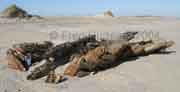
 This
single beam, approximately 15 ft. long, was discovered
October 16, 2004, along the base of the dune line, above
the high tide. Most of he metal spikes were badly rusted
and broken off close to the beams surface. It washed up
during the busy 2004 hurricane season, as it was not here
the previous April. This is one of several discoveries
made the same day along the beach between Ramps 23 and
27, which seems to be a hot spot for wreckage. This
single beam, approximately 15 ft. long, was discovered
October 16, 2004, along the base of the dune line, above
the high tide. Most of he metal spikes were badly rusted
and broken off close to the beams surface. It washed up
during the busy 2004 hurricane season, as it was not here
the previous April. This is one of several discoveries
made the same day along the beach between Ramps 23 and
27, which seems to be a hot spot for wreckage. |
Update
- A subsequent trip (12-29-04) just ten weeks after
this was first located found this piece of wreckage had
been fully uncovered, had moved a few feet to N 35.51254
W 075.47315, and was flipped over, presumably
by high water. |
|
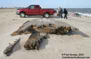
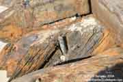
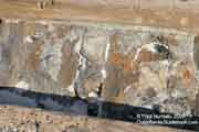
Unknown
Wreckage (ID: UNK-2_10-16-04)
Location: 2/10 mile south of Ramp 23,
Hatteras Island.
GPS coordinates: (as of October, 2004) N
35.52774 W 075.46931
How To Find It: Take Ramp 23 onto the beach and go 2/10
miles south. Large wreckage section located above high tide
line. (UPDATE: December, 2004 - This wreckage seems
to have disappeared. See "Update" below photos.)
|
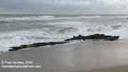
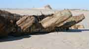
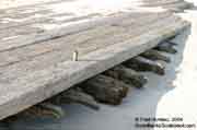
 This
large wreck section, shown in the panoramic photo at right,
appeared on the beach during Hurricane Alex, which hit the Outer
Banks on August 3, 2004. Judging from the excellent condition
of the wreckage, this section must have never been washed up
or exposed prior to Alex. It is so well preserved, it must have
been completely covered with sand, as there was no sign of algae
or barnacle growth at all. This
large wreck section, shown in the panoramic photo at right,
appeared on the beach during Hurricane Alex, which hit the Outer
Banks on August 3, 2004. Judging from the excellent condition
of the wreckage, this section must have never been washed up
or exposed prior to Alex. It is so well preserved, it must have
been completely covered with sand, as there was no sign of algae
or barnacle growth at all.
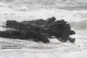
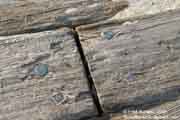
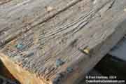
  The
wood is still light in color, and the brass
spikes which hold it together are still shiny, with a light
spotting of green patina. Dowel pegs are plainly visible all
over the structure. Even the wedge
in each peg is still easy to see. Many details
are clearly visible, unlike most pieces of wreckage seen
by the author on the Outer Banks. Even layers
of pitch which sealed the hull can be discerned. These photos
were taken October, 2004. It remains to be seen how long this
interesting wreck will be visible. Hopefully, many people will
have an opportunity to see it and wonder what the story is behind
it. The
wood is still light in color, and the brass
spikes which hold it together are still shiny, with a light
spotting of green patina. Dowel pegs are plainly visible all
over the structure. Even the wedge
in each peg is still easy to see. Many details
are clearly visible, unlike most pieces of wreckage seen
by the author on the Outer Banks. Even layers
of pitch which sealed the hull can be discerned. These photos
were taken October, 2004. It remains to be seen how long this
interesting wreck will be visible. Hopefully, many people will
have an opportunity to see it and wonder what the story is behind
it.
|
 |
 |
 |
 The
excellent condition and level of detail visible on this wreckage
is far beyond any others the author has found on the Outer Banks. The
excellent condition and level of detail visible on this wreckage
is far beyond any others the author has found on the Outer Banks. |
 |
 |
 |
 |
 |
 |
Update
- Just ten weeks after this excellent wreckage was first
found and photographed on October 16, 2004, it had vanished.
Two other wreck sites along this beach had uncovered considerably
during that time (the G.A. Kohler, and the wreck identified
as UNK-5_10-20-04). While this certainly indicates wave action
during that time, it would not seem to indicate a storm large
enough to move this wreck or wash it away. Judging from the
condition of this site when it was found, it is reasonable to
assume a university or museum took serious interest in this
site and possibly had this wreck hauled away for study. This
will be looked into. Unless the disposition of this wreck is
determined, the set of photos taken for CarolinaOuterBanks.com
may be all there is of this wreckage.
Update: January, 2010 - Upon inquiry concerning this
wreckage, a State Archaeologist with the NC Dept. of Cultural
Resources Underwater Archaeology Unit reported that they had
no record of this site and assured me it was not officially
removed, as that would only have occured if it posed a public
safety issue. He felt confident it was still in place but covered. |
Oh,
yes, there are lots more shipwrecks to see here.
Continue to Folklore and History - Page
Three > |
|